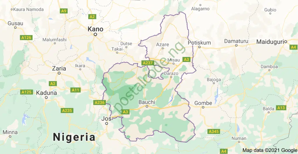
Bauchi State, situated in northeastern Nigeria, is recognized for its deep cultural roots and historical prominence. As one of Nigeria’s 36 states, Bauchi State is organized into 20 Local Government Areas (LGAs), each operating from its respective administrative headquarters. These LGAs play a crucial role in the governance and administration of the state.

Bauchi State Overview
- Total land area: 49,119Km2
- Capital: Bauchi
- Population: 6,997,314 (Male- 3,568,630 and Female- 3,428,684)
- Vegetation: Sudan and Sahel Savannah
- Major crops: Millet, Sorghum, Maize, Rice, Cotton, Ginger, Hibiscus, Gum Arabic, Garlic, Soybean, Sesame Seed, Pepper, Yam, Beans, Tomatoes, Sorghum and Groundnut.
- Solid minerals: Baryte, Gold, Cassiterite (Tin Ore), Columbite, Wolfram, Coal, Limestone, Lignite, Lead Zinc, Clay, Gypsum and Iron Ore.
Here is a list of the 20 Local Government Areas in Bauchi State:
- Alkaleri LGA
- Bauchi LGA
- Bauchi Town Area
- Bogoro LGA
- Dambam LGA
- Darazo LGA
- Dass LGA
- Gamawa LGA
- Ganjuwa LGA
- Giade LGA
- Itas/Gadau LGA
- Jama’re LGA
- Katagum LGA
- Kirfi LGA
List of Towns and Villages in Bauchi State
List of Bauchi State 20 Local Government Areas with their Headquarters
Below is an exhaustive list detailing all the LGAs in Bauchi State alongside their designated headquarters:
| LGA Name | Headquarters |
|---|---|
| Alkaleri | Alkaleri |
| Bauchi | Bauchi |
| Bogoro | Bogoro |
| Damban | Damban |
| Darazo | Darazo |
| Dass | Dass |
| Gamawa | Gamawa |
| Ganjuwa | Kafin Madaki |
| Giade | Giade |
| Itas/Gadau | Itas |
| Jama’are | Jama’are |
| Katagum | Azare |
| Kirfi | Kirfi |
| Misau | Misau |
| Ningi | Ningi |
| Shira | Shira |
| Tafawa Balewa | Tafawa Balewa |
| Toro | Toro |
| Warji | Warji |
| Zaki | Zaki |
Bauchi State has a diverse population, with people from various ethnic and cultural backgrounds. Each of these LGAs plays a crucial role in the administration and development of the state. The headquarters of the LGAs serve as the administrative centers where local government officials and departments are located.
If you would like to learn more about Bauchi State or any specific Local Government Area, you can visit the official website of the Bauchi State Government at www.bauchistate.gov.ng or the Bauchi State Local Government Service Commission’s website at www.bauchilgsc.org.
Bauchi State is a vibrant state with a lot to offer in terms of tourism, natural resources, and cultural heritage. Exploring the various LGAs and their headquarters can provide visitors and researchers with a deeper understanding of the state’s unique characteristics and traditions.
There are three agricultural zones in Bauchi state: Western, Northern, and Central. Bauchi, Toro and Dass in the Western zone, Gamawa, Dambam, Misau, Shira and Katagum in the Northern zone, Warji, Ganjuwa, Darazo and Ningi in the Central zone.
Disclaimer: The information provided in this article is based on the knowledge cutoff of January 2024. Please verify with official sources for any recent updates or changes.
